
What Happened: The Core Developments
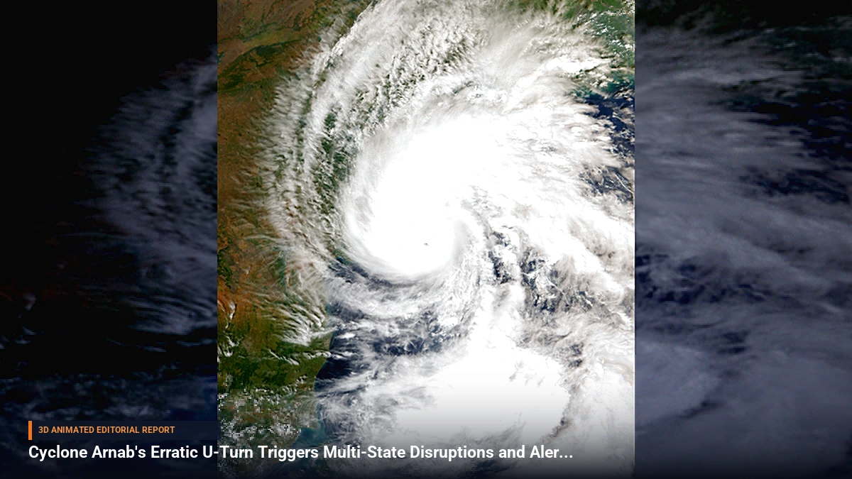
Cyclone Arnab has left a trail of destruction across parts of southern and eastern India, distinguished not only by its ferocity but by a deeply unusual meteorological path. Meteorological agencies tracked the storm making an unexpected loop where it entered the Indian mainland, temporarily exited, and then performed an erratic U-turn to enter the country yet again.
The storm severely battered India's eastern Andhra Pradesh state, resulting in at least three reported deaths alongside extensive damage to local homes, critical community infrastructure, and vast tracts of agricultural farmland. Infrastructure took a heavy hit as floodwaters inundated a vital railway bridge near Ichchapuram in Andhra Pradesh, forcing widespread train cancellations and major route diversions that stranded thousands of commuters. Meanwhile, the storm's extensive reach placed eastern urban centers on edge, with Kolkata facing persistent heavy rain and thunderstorms that prompted authorities to issue an urgent orange alert.
Background & Key Context
Tropical cyclones in the region typically follow a predictable parabolic or northwestward trajectory upon formation in the Bay of Bengal before dissipating over land. However, Cyclone Arnab’s behavior deviated significantly due to shifting steering winds and complex atmospheric pressures. As the system tracked across the subcontinent, it did not simply weaken and fade; instead, lingering atmospheric dynamics allowed it to loop back.
Compounding its lingering impact, meteorological forecasters have noted that moisture influx from the remnants of Cyclone Arnab is now colliding directly with an approaching western disturbance. This rare atmospheric crossover is setting the stage for an expansive, multi-regional weather event stretching far beyond the initial landfall zones.
Key Takeaways
- Erratic Trajectory: Cyclone Arnab executed an extraordinary loop, entering India, exiting, and re-entering in a rare atmospheric U-turn.
- Casualties and Property Damage: The storm's initial landfall in Andhra Pradesh tragically resulted in three deaths and widespread destruction of homes and crops.
- Transport Chaos: Heavy flooding inundated a key railway bridge near Ichchapuram, crippling rail traffic through cancellations and diversions.
- Urban Alerts: Kolkata and surrounding areas were placed under an orange weather alert amid persistent heavy downpours and thunderstorms.
- Northward Spillover: A merging western disturbance and lingering moisture from Arnab are forecast to trigger widespread rain across North India, including Delhi-NCR, Uttar Pradesh, and Haryana.
- Misinformation Spread: Disaster response efforts faced additional hurdles as unverified digital content, including an old video of an unrelated tornado in Odisha, was falsely circulated online as footage of Cyclone Arnab.
Impact, Analysis & Global/National Reactions
Local authorities and disaster management frameworks have been stretched thin managing the compound crisis. The combination of structural damage in southern coastal corridors and impending precipitation across the northern plains has put federal and state agencies on high alert.
Emergency response teams have focused heavily on rescue and relief operations in Andhra Pradesh while battling an secondary information crisis. Fact-checkers and local authorities had to actively debunk misleading media, such as an archival video showing a tornado in Odisha that was falsely repurposed on social media as live footage of Cyclone Arnab, causing unnecessary panic among residents.
What's Next: Looking Ahead
With meteorological departments forecasting widespread rainfall across Delhi-NCR, Uttar Pradesh, and Haryana due to the interaction between the western disturbance and Arnab's lingering moisture, municipal authorities are reviewing urban drainage systems and flood preparedness protocols. Transport networks remain on standby as regional lines work to clear infrastructure bottlenecks caused by the Ichchapuram bridge flooding, while disaster management agencies continue to monitor residual weather systems forming over regional waters.




Be the first to comment
Start a useful conversation around this story.